Healthy Lakeshore Properties

Many people who live on our lakeshores have chosen to live there for the tranquility brought by the water, the beauty of nature, and the opportunity to be close to nature and wildlife.  While it is easy to take these beautiful lakes for granted, we know of lakes within Nova Scotia where the water quality has quickly deteriorated making the lake unsafe, harmful for wildlife, and unusable for swimming. Often, this deterioration follows swift period of development on lakes. 

The best way to prevent that happening on our beautiful, healthy lakes is to understand the importance of lakes and the natural mechanisms that keep our lakes healthy.  When we understand how the lakeshore ecosystem works, each of us can take that into account when making decisions on how we live on and develop our own properties.  Ultimately, the best and easiest way to preserve the health of your lakes is to let the shoreline be and let nature work for you. 

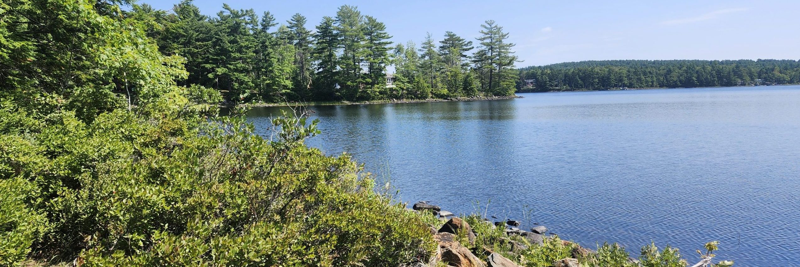
What is a Riparian Zone?

Riparian zones are the area of special grasses, shrubs, and trees that exist between the water and the upland terrestrial environment. It is an area that is rich in biodiversity, including species at risk and serves an essential role in maintaining the health of the surrounding ecosystem.  

Photo Credit: Crystal Doggett

How Much of my Riparian Zone Should I Keep Intact?

There are municipal regulations in place that prevent the removal of a percentage of vegetation within this buffer zone. These regulations are intended to protect this riparian area but as landowners, the message of why is not always clear. When it comes to riparian areas, you may wonder how far from the water’s edge should be protected? As with most things in nature, it is difficult to put a number on it. The simple answer is as much as possible. This is due to the numerous ecological services that riparian buffers can provide. 

Why are Riparian Zones Important? 

Riparian zones are important because they provide numerous ecological services. Ecological services can be thought of as the ways in which nature works for you! The best way to take advantage of these ecological services is simply to leave your shoreline be. Maintaining a healthy riparian buffer will naturally provide you with services such as: 

  • Flood control 
  • Maintaining good water quality 
  • Reducing the risk of cyanobacteria (blue-green algae) blooms 
  • Soil stabilization/erosion reduction 
  • Regulating water temperatures 
  • Providing habitat for native species
Photo Credit: Southwest Nova Biosphere Reserve

How can I Enjoy my Property While Maintaining a Riparian Buffer?

Recreation on and around the lake are a key part of enjoying your lakeshore property. Recreation with friends and family, and maintaining a natural lakeshore do not have to be mutually exclusive. Some ways you can maintain a healthy shoreline and riparian buffer while still enjoying your property are:

  • Create only a narrow path down to the lake
  • Use/create shared community docks and boat launches
  • Use naturally occurring beach areas- never create an artificial beach
  • Prune trees blocking your view instead of cutting them down

Species at Risk Habitat

Riparian zones and lake shorelines provide vital habitat to a plethora of plants, animals, and insects. Many of these plants and animals are species at risk in Nova Scotia. These species are in danger of disappearing from our landscape and our actions have direct impacts on their habitat. These species at risk rely on unaltered riparian and shoreline habitat for their survival.

Atlantic Coastal Plain Flora

  • Eastern Lilaeopsis  
  • Golden Crest  
  • Long’s Bulrush 
  • New Jersey Rush  
  • Pink Coreopsis  
  • Plymouth Gentian
  • Redroot  
  • Spotted Pondweed  
  • Sweet Pepperbush 
  • Tall Beakrush  
  • Thread-leaved Sundew  
  • Tubercled Spikerush  
  • Water Pennywort  

Photo Credits: Nova Scotia Nature Trust; Mersey Tobeatic Research Institute

Reptiles

  • Blanding’s Turtle 
  • Wood Turtle 
  • Eastern Painted Turtle 
  • Snapping Turtle 
  • Eastern Ribbonsnake 

Photo Credits: Brennan Caverhill; Jeffie McNeil

Certain practices on our shorelines can cause unintended consequences for the health of the lake. Leaving your shoreline in its natural state is the best way to preserve the health of your lake. The more we alter our shorelines, the more we interfere with the natural processes that keep it healthy.

Incompatible Practices

  • Any alterations below the lakes ordinary high-water mark
  • Hard armoring 
  • Raking shorelines 
  • Infilling 
  • Removal of shoreline vegetation 
  • Artificial beaches

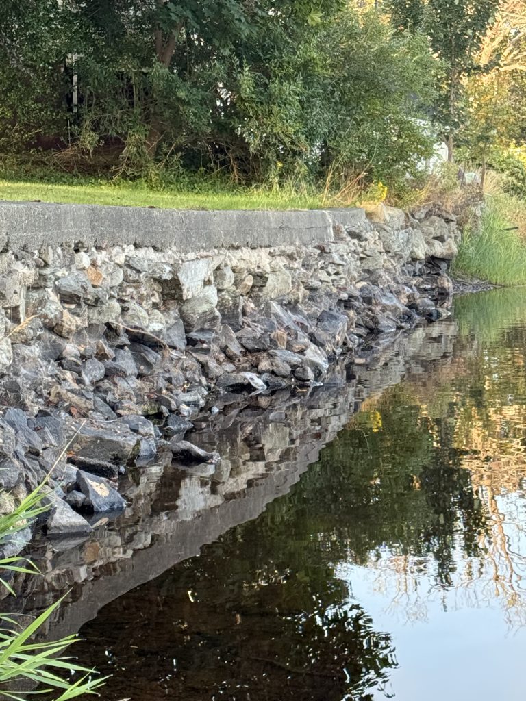
Potential Effects of These Practices

  • Blue-green algae blooms 
  • Increased water temperatures
  • Decreased water quality 
  • Decreased populations of fish and wildlife 
  • Increased rates of erosion 


If you have already altered your shoreline by developing it in ways that are incompatible with healthy riparian zones, it is not too late! There are resources available that will help you naturalize your lakeshore, while still allowing for recreation. There are several groups working to help restore lakeshores in Nova Scotia, with a special focus in Southwest Nova Scotia/Kespukwtik. None of these groups exist to shame, report, or point fingers at anyone. They are simply passionate about healthy, naturalized lakeshores and willing to help. 


Restoration Resources

Southwest Nova Biosphere Region Restoration Project 
The Southwest Nova Biosphere Region has started a riparian restoration project. They can assist you with restoration of your riparian areas and offer free native shoreline plants to aid in the process. 

Green Shores for Homes 
Green Shores for Homes is a project that is new to the Maritimes, which helps waterfront homeowners restore natural shorelines. It is a is a voluntary, incentive-based rating program that provides positive steps to reduce the impact of residential development on shoreline
ecosystems.

Helping Nature Heal 
Helping Nature Heal is an ecological landscape design company based out of Bridgewater, Nova Scotia. They have worked on many shoreline projects, with a focus on Living Shoreline techniques.  

We are starting a conversation with and among landowners about our roles in keeping lakes healthy. When landowners are aware of the importance of the natural mechanisms that healthy riparian areas and lakeshores provide and take them into account as they develop their property, they are supporting the aspects of lakeshore living that have drawn them to the area. Protecting the lake and surrounding areas means the lake continues to provide habitat for wildlife and species at risk as well as for recreation and enjoyment by people. 

The Kespukwitk Conservation Collaborative is coming to landowners with respect.  We want to have an exchange of information so that we understand your concerns regarding lake health.  Understanding the importance of lakeshores will help you make informed decisions. This way, when you chose what you do on your property you can try to help nature do its job. It is ultimately each landowner’s choice what to do on their property.

Photo Credit: Olivia Burchell

Lakeshore Guardians are lakeshore landowners who have signed a commitment to keeping the lakes they live on healthy through the use of best practices in shoreline development. They understand the vital role they play as individuals in the overall health of the lake, lakeshores, and surrounding watersheds. Sign the pledge and become a Lakeshore Guardian today.

Sign the Pledge!

Invasive Species Reporting and Prevention

Invasive species threaten the plants and animals in your community. Unfortunately, many invasive species have made their way to the waters, forests, and shorelines of Nova Scotia. You can help by reporting any sightings of invasive species to the Nova Scotia Invasive Species Council (NSISC).  This data helps gauge the distribution and abundance of invasive species in the province and informs efforts to stop the spread of these species.

Common invasive species you may encounter in your lakeshore community include: 

  • Chain Pickerel 
  • Smallmouth Bass 
  • Common Reed 
  • Glossy Buckthorn 
  • Hemlock Woolly Adelgid 
  • Purple Loosestrife 

You can also participate in NSISC programs, such as the “Clean, Drain, Dry” program. This is a simple way you can help stop the spread of aquatic invasive species that may be hitching a ride on your boat, canoe, kayak, paddle board, or even fishing gear.

Species at Risk Monitoring

We rely on volunteers to help monitor at-risk species across Southwest Nova Scotia/Kespukwitk. Turtles, bats, snakes, plants and lichen motoring efforts can all use your help! Visit our Volunteer page to find out how you can help. 

Please report any sightings of species at risk using our Report a Sighting page. You may be the first to discover a population of at-risk species in Nova Scotia.

Community-Based Water Monitoring 

Are you interested in helping to preserve the water quality in your community? Monitoring over time allows for early warning of environmental problems. Water quality monitoring programs exist in numerous communities in NS and resources are available for communities who are interested in starting a program. Here are a few of these resources: 

Atlantic Water Network  

Coastal Action 

Annapolis River Guardians 

Tusket River Environmental Protection Association  

Knowing and following the watercourse bylaws in your municipality is the best starting point to conserving your lakeshore property. While it is a requirement to follow the minimum watercourse setbacks and vegetative buffers outlined in your municipality’s bylaws, going above and beyond these recommendations can provide the most benefits to your lake. Refer to the Healthy Lakes and Wetlands Stewardship Guide found in the Additional Resources tab for more tips on how to best conserve your lakeshore. Below is a list of watercourse setbacks and vegetative buffers outlined in the land use bylaws of Kespukwitk municipalities.

*These bylaws are current as of November 2025

Region of Queens Municipality

Where a lot abuts a significant watercourse, as identified on Schedule ‘B’, no development shall be permitted within 15.24 horizontal metres of the ordinary high water mark of the watercourse.

Learn more here.

In relation to a development, no natural vegetation shall be removed within 15.24 metres of the ordinary high water mark of a significant watercourse, as identified on Schedule ‘B’, except: (a) to the extent necessary to accommodate developments listed in Subsection 6.33.3; and (b) removal of vegetation to a maximum of 25% of the water frontage to facilitate views.

Learn more here.

Municipality of the County of Annapolis

No excavation, infilling, construction, tree, stump and other vegetation removal, or any alteration of any kind other than maintenance as may be necessary to maintain vegetation and preserve the shoreline shall be permitted within 15.2 m (50 feet) of the edge (mean ordinary high water mark) of any watercourse, except for wharves, marinas, boardwalks, pedestrian or vehicular bridges, and buildings and structures related to boating clubs, ship chandlery offices, marine fueling stations, fishery and marine related uses, boat construction, building and repair facilities, boat and marine sales, service and rental facilities, and any other uses so exempted in this Bylaw. The watercourse setback distance is defined as being part of any side, rear, or front yard requirements.

Learn more here.

Town of Annapolis Royal

No permanent development is allowed within 6 m (19.6 ft) of the mean high-water mark of Allains
River or the Annapolis River, with the exception of trails, boardwalks, decks, bridges, boat ramps,
marine haul-up and related facilities, boat houses, dykes, bank armouring and docks.

Learn more here.

Currently no explicit bylaw regarding removal of vegetation along watercourses.

Learn more here.

Town of Middleton

Currently no explicit bylaw regarding setbacks along watercourses.

Learn more here.

Currently no explicit bylaw regarding removal of vegetation along watercourses.

Learn more here.

Municipality of the District of Yarmouth

For development in any zone an undisturbed buffer of 12.0 metres shall be maintained between any structure or developed portion of the lot and the ordinary high water mark of all watercourses. For greater clarity, buffers greater than 12.0 metres may be required in some zones (check zone standards). 20 Municipality of the District of Yarmouth Land Use By-law 6.31.2 Infilling or removal of material shall not be permitted within the watercourse buffer except for minimal disturbance incidental to a permitted undertaking.

Learn more here.

In the watercourse buffer area, the natural flora and fauna shall remain substantially undisturbed except for penetrations for developments permitted by Subsection 6.31.5, below. Good ecological practices designed to minimize disturbance of natural shoreline areas shall be encouraged for all activities and developments within the buffer and all developments on properties abutting watercourses in the Municipality.

Learn more here.

Municipality of the District of Argyle

Where, in the By-law, a front, rear, or side yard for a main or accessory dwelling is required, and property upon which the main or accessory dwelling is located abuts an identified watercourse and/or the oceanfront, the minimum required setback for a front, rear, or side yard, or a combination there of, shall be no less than twenty-five (25) feet and shall not be permitted to be varied.

Learn more here.

Currently no explicit bylaw regarding removal of vegetation along watercourses.

Learn more here.

Municipality of the District of Shelburne

No excavation, infilling, construction, tree, stump and other vegetation removal, or any alteration of any kind other than maintenance as may be necessary to maintain vegetation and preserve the shoreline shall be permitted within 15.2 m (50 feet) of the edge (mean ordinary high water mark) of any watercourse, except for wharves, marinas, boardwalks, pedestrian or vehicular bridges, and buildings and structures related to boating clubs, ship chandlery offices, marine fuelling stations, fishery and marine-related uses, boat construction, building and repair facilities, boat and marine sales, service and rental facilities, and any other uses so exempted in this Bylaw. The watercourse setback distance is defined as being part of any side, rear, or front yard requirements.

Learn more here.

Town of Lockeport

Currently no explicit bylaw regarding setbacks along watercourses.

Learn more here.

Currently no explicit bylaw regarding removal of vegetation along watercourses.

Learn more here.

Municipality of the District of Barrington

In all zones where development is undertaken on a lot which borders a watercourse or the ocean, an undisturbed buffer of 12 metres is required to be maintained between the high-water mark on either side of a watercourse and any structure or developed portion of the lot. Infilling or removal of material is not permitted within the buffer except for minimal disturbance incidental to a permitted undertaking. In the watercourse buffer area the natural flora and fauna is to remain substantially undisturbed except for penetrations for wharves and boat launches. Moderate thinning of tree cover in the buffer area to enable views is permitted and good ecological practices designed to minimize disturbance of natural shoreline areas are encouraged when undertaking all activities within the buffer and all developments on properties abutting watercourses in the Municipality.

Learn more here.

Town of Clark’s Harbour

Currently no explicit bylaw regarding setbacks along watercourses.

Learn more here.

Currently no explicit bylaw regarding removal of vegetation along watercourses.

Learn more here.

Municipality of the district of Lunenburg 

Currently no explicit bylaw regarding setbacks along watercourses. MODL is in the process of updating their land use bylaws.

Learn more here.

Currently no explicit bylaw regarding removal of vegetation along watercourses. MODL is in the process of updating their land use bylaws.

Learn more here.

Town of Bridgewater

No building or structure, parking space, or loading area shall be located within 8m (26ft) or less of a significant watercourse, as identified on Map 6 – Environmental Constraints of the Municipal Planning Strategy.

Learn more here.

Currently no explicit bylaw regarding removal of vegetation along watercourses. MODL is in the process of updating their land use bylaws.

Learn more here.

Town of Lunenburg

Currently no explicit bylaw regarding setbacks along watercourses.

Learn more here.

Currently no explicit bylaw regarding removal of vegetation along watercourses.

Learn more here.

Town of Mahone Bay

All development, with the exception of those developments listed in Subsection 5.53.3, shall be prohibited within 10.0 horizontal metres of the ordinary high water mark of watercourses identified on Schedule ‘C’ of this Bylaw.

Learn more here.

In relation to a development, no person shall alter land levels and no natural vegetation shall be removed within 10.0 horizontal metres of the ordinary high water mark of watercourses identified on Schedule ‘C’, except: (a) to the extent necessary to accomidate developments listed in Subsection 5.53.3; and (b) removal of vegetation to a maximum of 25 percent of the water frontage to facilitate views.

Learn more here.

Municipality of the District of Chester

All uses requiring a development permit shall place all buildings at least twenty (20) m from the ordinary high-water mark of any wetland, watercourse or water body.

Learn more here.

With regard to watercourses and water bodies: (i) maintenance of a vegetated buffer of twenty (20) m in depth from the ordinary high-water mark of a watercourse or water body; (ii) retention, replanting and maintenance of the vegetated buffer, in tree cover and understory vegetation to at least 75% of the linear water body frontage of the buffer, and not as a maintained, mowed lawn; (iii) allowance of a 3.5 m wide opening in the vegetated buffer for access to watercourses and water bodies by means of docks, decks and pathways; (iv) allowance of small accessory structures shall be permitted within the vegetative buffer so identified.

Learn more here.

Municipality of the District of Digby

Currently no explicit bylaw regarding setbacks along watercourses.

Learn more here.

Currently no explicit bylaw regarding removal of vegetation along watercourses.

Learn more here.

Municipality of the District of Clare

No excavation, infilling, construction, tree, stump and other vegetation removal, or any alteration of any kind other than maintenance as may be necessary to maintain vegetation and preserve the water’s edge shall be permitted within 20.1 m (66 ft) of the mean ordinary high water mark of any river, brook, stream, wetland, or other inland watercourse and any portion of the coastline not shown on the Coastal Sensitive Area Map except for parks, trails, boardwalks; pedestrian or vehicular bridges; interpretive signage associated with the foregoing; and buildings and structures related to public parks and trails located within the protected area; public water, wastewater, and stormwater services; wharves; marinas; boating clubs; ship chandlery offices; marine fueling stations; fishery and marine-related uses; boat construction; building and repair facilities; and boat and marine sales, service and rental facilities.

Learn more here.

Town of Berwick

Currently no explicit bylaw regarding setbacks along watercourses.

Learn more here.

Currently no explicit bylaw regarding removal of vegetation along watercourses.

Learn more here.

Municipality of the County of Kings

All permitted structures (Amended October 1, 2024, File P21-01) in all zones shall have a separation distance of at least 50 feet from the edge of the bank of any watercourse, in accordance with policies 2.4.8 and 2.4.9 of the Municipal Planning Strategy. Notwithstanding clause (a) above, the watercourse separation distance shall be reduced to 30 feet along the north side of the Cornwallis River between Terry’s Creek and the Port Williams Sewer Lagoon Road and south of Kars Street and Belcher Street. Notwithstanding clause (a) above, livestock operation buildings or manure storage facilities shall have a separation distance of at least 100 feet from the edge of the bank of any watercourse. Clauses (a), (b) and (c), above, shall not apply to an approved public drainage system. Lands covered by watercourses shall be subject to the requirements of the Environmental Constraints (O1) Zone.

Learn more here.

Any use of a waterfront lot shall adhere to the requirements noted below. (a) Vegetation within the shoreline setback shall remain undisturbed. (b) Notwithstanding section 9.3.4.5(a) above, up to 35 per cent of the area within the required shoreline setback may be cleared to permit passage to the lakeshore and a filtered view of the lake. (c) The soil mantle within the required shoreline setback shall not be altered by cutting, filling, or recontouring of the natural grades or otherwise, to every extent possible. (d) Any steep slopes or wetlands shall be maintained in a naturally vegetated state. (e)Nothing in this section shall prevent the removal of dangerous or diseased vegetation.

Learn more here.

Town of Wolfville

No structures shall be erected within 8 metres of the top of banks of watercourses as idenfied on Schedule B: Development Constraints Map. An erosion and sedimentation control plan prepared by a qualified professional will be required with any application for development of any lot within 15m of a watercourse.

Learn more here.

Currently no explicit bylaw regarding removal of vegetation along watercourses.

Learn more here.

Town of Kentville

Currently no explicit bylaw regarding setbacks along watercourses.

Learn more here.

Currently no explicit bylaw regarding removal of vegetation along watercourses.

Learn more here.